East Fork Pukaskwa
East Pukaskwa Trip Report
As the details of memory fade, I tried to use the traditional tools of journalism to describe this trip. It’s about a year ago now we were getting our ducks in a row to drive north.
Who

Exploding our gear at the put in, trying to convince ourselves that the bugs weren’t that bag
Jeremy Hutchins, Harrison Whitten, Nick Milo and Jonathan Rugh kayaked the river and the lake.
David from Naturally Superior adventures provided a take out, and shuttle services. Also a good laugh and sage advice. Valerie? was a wonderful Belgian woman who is the cook and occasional shuttle driver for Nat Superior. ________ drove our shuttle, and entertained us with stories of life up north and made us very nervous about bears.
________ was the very friendly barkeep at the Lakeview Hotel.
There was also a large group of Canadian YouTubers who were putting on the Dog river the same day. They included the famous Ted and Jim Baird who have shows on Nat geo, Xander Budnick, another Budnick brother, someone who goes by @lostinthewoods and some others in the group.
Tim Horton provided coffee, donuts and egg sandwiches.
What
We kayaked down the rarely run East Pukaskwa River into Lake Superior. It does not have a gauge, but like most rivers in that zone, the main Pukaskwa gauge is used. We had found a recommendation online that 4.1 on the main would be enough water. We have judged that is not accurate, and more water would be better. The main Puk gauge had been holding at 4.2-4.1 for about the week preceding us. I would guess that if the main were higher and on a downward trajectory to 4.1, it would be better. However, holding at that level for a week gave us a little less than an ideal minimum, in my opinion.
Where

Amazing beach and surf at ‘The Flats’ along Lake Superior
The nearest town is Wawa Ontario, along the northeastern shore of Lake Superior.
When
We all met up in Beckley, WV on Friday May 17th 2024. We drove for a few hours into the night and slept in a state park near Athens, OH. The next day, we completed the drive to Wawa and stayed at the Lakeview Hotel. We put on the river, Sunday May 19th around 1pm. We reached the shores of Lake Superior mid day on Tuesday May 21st. A very bad storm system moved over the lake on the 22nd. We were windbound at a campsite along the lake called ‘The Flats” on Thursday May 23rd. The weather cleared and we paddled the remaining miles to the Michopechian First Nations village near Wawa on Friday 24th. We drove late into the night, slept in a hotel on the southern side of the Mackinac bridge. Jeremy and I made it back to Blacksburg Saturday the 25th.
Why

A drop with a sharp reconnect halfway down, needed more water!
This is always the hardest one to answer. Speaking for myself, it presented a great opportunity to do something that very few have reportedly done before. We enjoyed the fact that there was not much previous written beta, and that we would push our mileage even more than our previous trip to the area. One of my favorite parts of this kind of trip is paddling around the bend with no idea what's in store.
When I say ‘a few people’, I can’t speak with much confidence. Let's just say that I have no idea how many people have been down this river before. There were a few well documented trips, but still pretty scant information which made it seem all the more alluring. The main Pukaskwa is very well documented, with several old guide books written about it. The Dog river is also very well documented with videos and trip reports. We estimated the EF Puk dropped the same elevation as the Dog, over a similar distance but a smaller watershed. Based on some maps and aerial photography, we knew there were rapids, and we did know there were a few big sets right close to the put-in. It also had very simple and cheap logistics, just like the Dog. Speaking for myself, I had become enthralled with the landscape around Lake Superior and was looking forward to putting in some miles down the lake shore.
Narrative account
We had a very simple meet up and drove straight to Wawa Ontario, with a standard supply stop in the ‘Soo quickly dispatched and our bellies full of Wacky Wings, we cruised along the Trans Canadian Highway arriving at our hotel just as the sun was setting. The next morning, we quickly exploded all our gear along the classic ‘how am I going to fit all this stuff in my kayak’ banter we made our way to a mid day meet up at Naturally Superior to meet up with our shuttle driver.
As we arrived, there were camera tripods and large canoes taking up most of the one lane entrance road. Low and behold, it was a large group of well known Canadian Youtoobers, and they were headed to the Dog river that same day! We were very excited by this encounter, along with the general eye rolls of people filming b-roll loading their canoes onto a trailer. I mean, do we really need to see y’all packing barrels so much?? We were glad to see David, the owner of the outfitter, and we were quickly on the road again waiting for the youtoobers to move their cameras on the way out. We stopped, gave them some schwag from our primary expedition sponsor, the Virginia Alpine Institute, and made sure they had enough chapstick to prevent lip injuries.
We were again happily on the road again, getting the finer points of bug dope application from our driver. Don’t get it near your eyes, or goretex, or your sunglasses etc. The weather was much colder the last time we were there, so the bugs were not out on their seasonal attack and only 50% of the team had head nets.
The put in was a very small creek flowing through a large culvert. Since it was past noon, and we were leaving all luxuries aside, we changed into paddling gear and drank a beer or two since they were still cold in the back of the truck.
I think one reason that the EPuk is not often paddled is that you can’t drive ‘straight’ to the put in. We had to paddle through a small feeder creek, about a ½ mile as the crow flies. As the creek flowed, it was a very meandering mile. At times, it wasn’t even 10 feet wide, a classic boreal swamp creek with willows and tall grasses and tannic water. A great place to find a moose, or beavers. While we didn’t come across either of those, we did encounter two downed trees, but they were quickly dispatched.
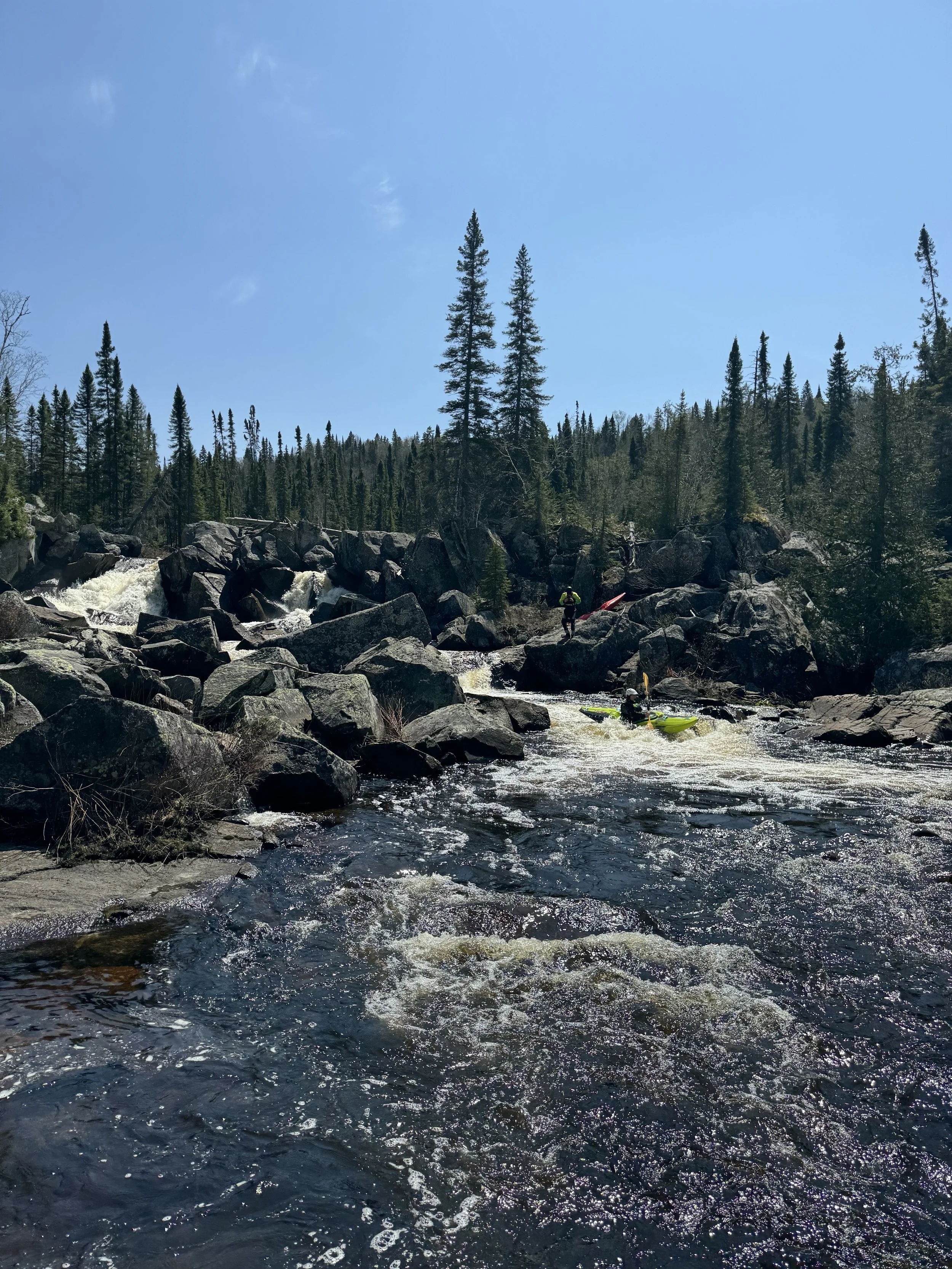
The main river seemed to be flowing just fine. It was wide, deep and had current. However, reaching the first real rapid, we started to sense it was a little low. The first real rapid was a wonderful looking straightforward 10 ftish ledge, but the landing zone was a little boney. 6 inches more water, we could have gone straight off it! The boats are always the heaviest on the first day, so we followed in the grand canadian canoe tradition of portaging.
We knew there would be some bigger drops right away, and some fun class 2 led us to another beautiful bedrock cleft in the river with a giant evergreen tree blocking the entrance. This time, the river split around a big rock formation in the middle, with the left side being rather manky and burly, the right side was an easier way down through a series of 4 ledges. It would have been pretty straightforward, but more wood caused some trepidation. Again, taking the dry line around the wood, left us with the last half of the rapid, and a little mank. Did I say we needed 6” more water? Funneling everyone through and around the bend to a massive cataract. It was a set of double falls, the upper dropping about 40 ft onto rocks, the lower dropping more than that onto rocks. What a sight! We were able to stay out of the banks of the river and portage down a rock spine in the middle, lowering the boats around the first ledge. We jumped back in our boats and ran a short rapid and ferried above the last waterfall the RR shore. We had to bushwhack around to the base of the big falls. It was such a great place!
Below the falls, the river pinched down and made a turn and we had a mile or so of very tight read and run paddling. My memory is that it turned very dark and the trees were right up the banks. They created a tall cathedral ceiling overhead. Hooting and hollering seemed like appropriate behavior in this holy place, and we wove our way downstream. The river rock opened up and we were again in the sunlight, and faced with a stout rapid. Everything looked good to go, except the final plunge. The landing zone was not super friendly looking and seemed to have some rocks in the foam pile (but if we only had 6” more water!!). We ran down the first few moves, took out above the last ledge and hopped down the rocks and we all became quickly pinned in some boney ass class 2 runout. Lots of cursing and trying to not let your boat fill up with water left lots of laughs and cursing. Jeremy got pinned and needed a hand, not quite a ‘grab that bitch’ situation because I was already out of my boat trying to un-pin my own about 4 feet away. The situation left a little shark bite out of the upper edge of his beautiful hand made custom wooden paddle built by the most handsome paddle maker in North America. Luckily there was an island just downstream that was suitable for us to set up camp. A little gorilla tape, and the shard was held in place for the remainder of the trip and now is fully repaired.
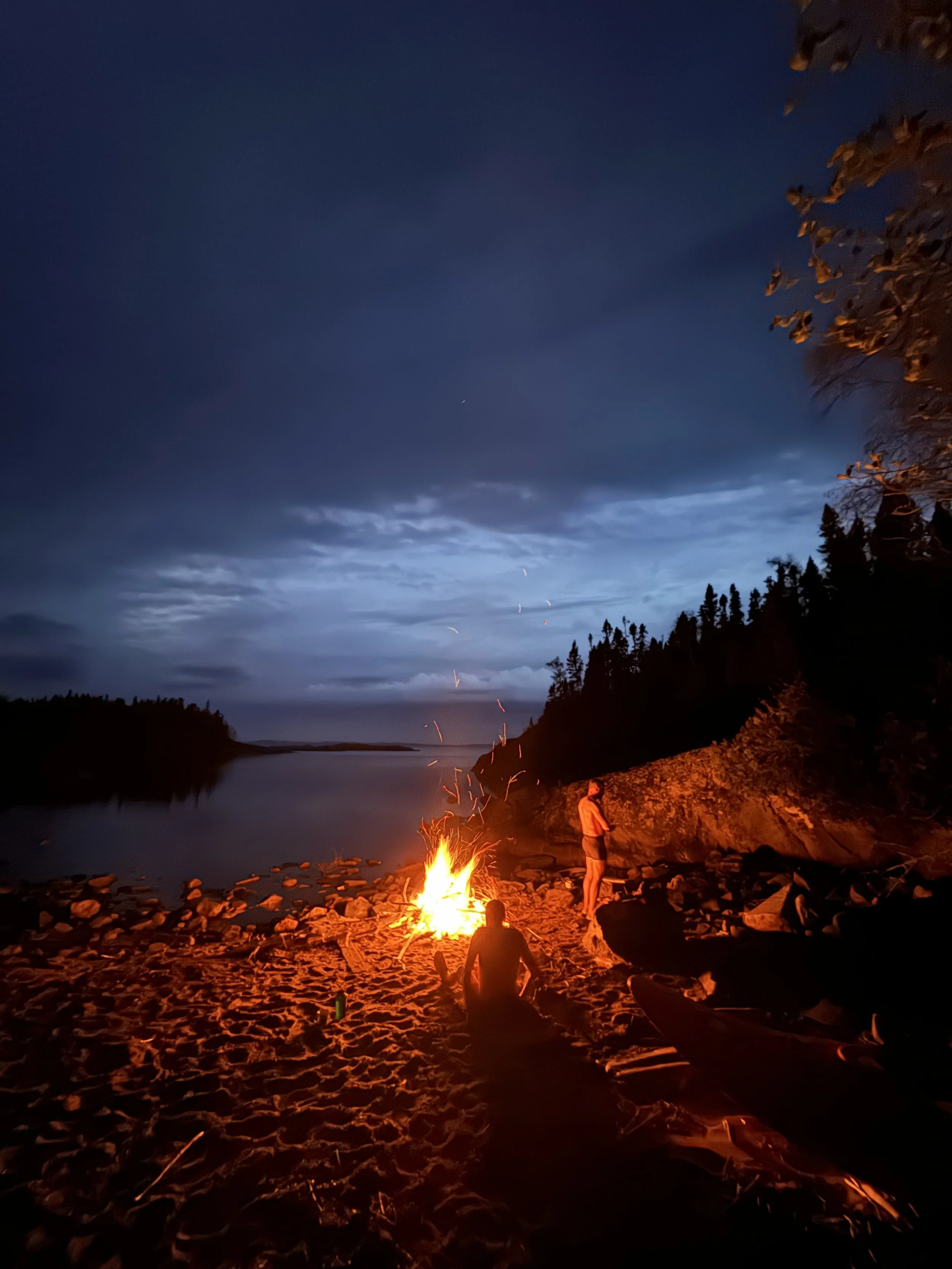
We quickly stopped on this small island covered in moose tracks and quickly set up camp. Cocktail hour has arrived and I got everyone feeling good with a wonderful Gin infusion with tonic water. I had thrown an extra few beers in the boat at the put in, and that night I calculated that my boat lost 8lbs of carried liquid weight!
Day two of the river settled into a nice pattern of wide shallow water to tight deep box canyons. Box canyons sound really cool and gnarly, but they would generally contain a class 3 exit drop. It was a ton of fun! The lower water gave us easy access to jump out of your boat, look over the next rapid and call out the line to the rest of the group. We made some fun miles with some bigger sets as we made our way downstream. Sadly an awesome 4 tiered rapid had some wood blocking the entrance and a few sharp rocks that could use some more water in the upper half. However, we could easily scramble around and run out the last ledges! We also encountered a wonderful looking 15 footer, but much as the other rapids, the clean lip had a sharp looking reconnect halfway down, which as much of the other drops, would have been covered up with 6” more water . . .
We had some maps from the Canadian Government and they indicate rapids with horizontal tick marks across the river. From a boating perspective, those little lines could mean a class 2 riffle, or a 70ft unrunable waterfall. Topo lines can help suss out the truth beforehand, but they really are hard to tell what you are getting into. The last 5 miles of the run had a nice looking gradient with the topo lines, and a great spacing of rapid lines on the map. Aerial photography was inconclusive as to what we would find. Our spirits were high, thinking we would have some nice bedrock stuff like the upper portions of the river . . . . but we were disappointed to find cobble bars for miles. Again, with 6” more water, we would have simply floated down them with some fun continuous class 2. But the low water had us cursing and banging and monkey clawing our way down. We had to get out and drag for a bit and we did have a ‘grab that bitch’ moment with a pinned boat in the middle of the river. I quickly pulled over and ran/swam behind the boat and gave it a big pull. All in all, I still had fun looking around at the soaring granite cliffs and big trees. We were still in a beautiful place with friends!
We made it to the main branch of the Pukaskwa later that afternoon, found a big island with a great cobbly beach to set up camp. Blue skies, enough gentle breeze to keep the bugs down and some cocktails lead into a wonderfully colorful sunset.
Continuing down the main branch of the Puk was awesome, and had some really cool bouldery rapids till we hit the big sets at the lake. Upper Stiles falls was very straightforward and a ton a fun (photo) which then turned the bend and went into Stiles falls proper. A lot of canoeists just portage both rapids in one push, but we wanted to see how close we could get to Stiles falls. There was a cool bedrock gorge leading into it. We picked our way down and eddied out right above the point of no return. We had a simple rope haul to get our boats off the rocks into the woods and onto the well worn portage trail. We scrambled around to get a good look at the falls, and they were quite impressive! It’s a series of 3 waterfalls all looking to be about 20-30 feet tall each. I’ll say it- these falls are runnable. Not by me, but at the right level I think they could go. You would want low water and a decent size safety crew, a long time setting it all up, but I think it’s a go. Maybe someone has run it before, I don’t know!
A short drag through the woods has us looking into the blue wonders of Lake Superior! A nice lunch and a cup of hot coffee on the river mouth, and we shoved off for a few days of lake life. We put in about 10 miles that afternoon, enjoying a glassy lake and amazing scenery. We ended the day in a small inlet that had a mediocre beach in it. A wonderfully clear night, we made a big bonfire and settled in because we knew there was a storm brewing. In the middle of the night, a big thunderstorm rolled in and the winds shook us all night. Nobody slept very well due to the large wolf tracks we found around camp and the storm made for a restless night. When we awoke, everything, and I mean everything was covered in slugs! The inside walls of my tarp, drybags, bivy sack, gross!!! The storm has subsided, but the sky was gray and foreboding. The lake was choppy as hell. Our camp sucked, and there seemed to be no wind out on the water, so we cleaned off all the slugs and headed out for the open water.
Before the storm, we were aiming for a big mileage day to get us all the way to the mouth of the Dog river. That would set us up nicely to finish the day after. However, the lake had another idea in store. What was glassy and smooth the day before turned into giant rollers that were well over 6 feet tall. We went really far out from shore in an attempt to get out of the waves and did our best to make miles. Luckily there was no wind, just waves. We put in some big effort and found another cove to pull into for a lunch break. We were able to surf some fun waves into a little cove and sit on solid ground for a bit. Unknown to anyone, Harrison was fighting some sea sickness from the ups and down of the waves and relieved himself of his stomach contents. We were not making great mileage and working really hard, so we aimed for a big area along the shore called ‘the flats’. We knew it would be a safe harbor and some well established campsites. We pushed to the big bay of the flats and surfed our way into a giant sandy beach. The waves were breaking about shoulder/head height and it was a wonderful way to end the day. We found an old fire ring and some cleared tent areas and even a pit toilet, paradise! Through a little garmin texting, our home base expedition support and logistics provided by the Virginia Alpine Institute reported constant 30 mph all night and day, blowing east.
The wind blew all night, but I slept like a baby. When we all crawled out of our shelters, we could see the bay in front of us had even bigger waves than the day before and the wind was cutting right through our tree sheltered camp. I promptly put on all of my clothes and tried to find a less windy spot to cook breakfast. We decided to at least hang out at camp for the morning and see if conditions changed. We explored the forest around camp and went out onto a rocky peninsula in the lake. If you didn’t watch your step, the wind would knock you off balance. The big rolling waves from the day before turned into whitecaps, and if I’m being honest, were way scarier than anything we encountered on the river.
I was rather bored sitting around all day, but I felt that being bored is better than going out in conditions that felt sketchy to me. Our thought process was that the wind was at least blowing in the direction we needed to go, but there would be little chance to stay as a group and even harder to get to shore further down the lake to set up camp the next day. My dearest emergency contact on my Garmin Inreach Phil kept us up to date with the weather earning him the nickname ‘Bad News Phil’. He finally gave us some good news that the wind was to die down overnight. All in all, we traded a slow day of putzing around camp with being safe and then pushing a huge day the next.
Under the Influence
We shoved off from camp around 5am and drove hard to the east. Perfect weather, perfect lake conditions! By 9am or so, we hit our first major landmark, the mouth of the Dog River. We were very excited to see if the Youtube crowd had made it to the lake, and as luck would have it, they were tearing down camp when we arrived. We pulled up to the gravel jetty, got out some snacks and I pulled out the last of my bourbon. We cautiously approach the group with these peace offerings. Turns out they were all very friendly and we swapped river stories from the Dog, talked about other trips and like the fabled ‘bread and fishes’ episode from the New Testament, somehow the bourbon in the flask made it all the way around.
We watched them reel in a big ass fish, twice, and then we shoved off for the big push to the takeout. We found that with the flat lake and no wind we were able to get about 4 miles per hour down the shoreline, and that we all ran out of water and needed a little stretch/snack break after about 90 minutes of paddling. If clouds rolled in, I would get chilly and when they rolled away, I would get hot and sweaty under the sun. Most of the day involved getting hot and laying in the lake to cool off, filtering water, eating each other's snacks and putting your head down and paddling. Our hard work paid off and we rounded the bend to the final pitch into the bay and our vehicle in the Michopitchen village. The final bay into the village was gorgeous with deep blue water, massive rock outcroppings and sandy beaches and sandbars undulating around the rocks.
We had some awesome conversations with people as we exploded our gear and packed up to head home. After a quick stop back at Naturally Superior to give David a quick trip report, we decided to just turn and burn back to the states! Nothing but a little truck time brought everyone back home, hungry for another grand adventure together.
We found the correct culvert!

Important landmark, this is probably the best visual gauge on the Dog River. We drove past it on our way to the EF Pukaskwa on Paint Lake Road. Just a note, this is also low. When we ran the Dog two years previous, the water was richter high and flowing over the top of this old bridge pillar. If I was going to do the Dog again, it might just be worth it to put in here, or at least drive a mile or so down the road to check the level before putting on at the normal spot.